MOYA BOULEVARD CAPACITY
Project Overview
| Label | Value |
|---|---|
| Status | Upcoming Projects |
| Project Details | 211010 |
| RTC Project Manager (PM) | Ashley Hurlbut, P.E. |
| RTC Engineering Department | (775) 335-1861 |
| Design Firm | Jacobs Engineering |
| Construction Contractor | To be determined |
Project Description
Improve safety, mobility, and roadway capacity by widening Moya Boulevard from two lanes to four lanes with a center two-way left turn lane between Red Rock Road and Echo Avenue. The project will enhance multimodal connectivity by replacing on-street parking with a continuous shared-use path on the northbound side and constructing a continuous sidewalk along the southbound side. Existing RTC transit stops will be maintained.
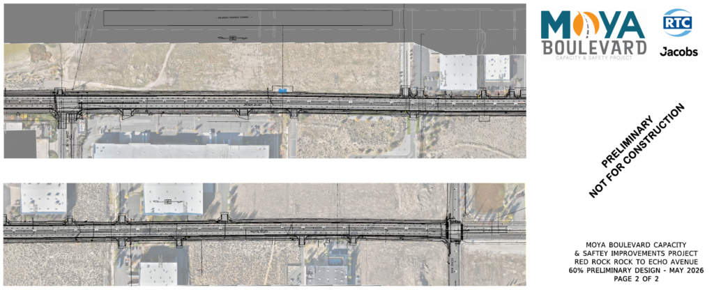
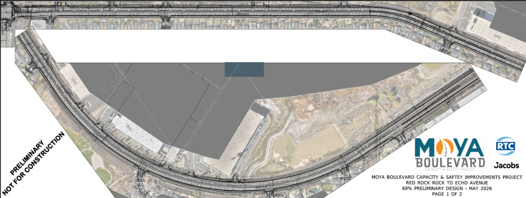
Roll Plots
Silver Lake Water Monitoring Livestream
The City of Reno and Washoe County monitor water levels within the North Valleys closed basins and provide timely responses to rising lake levels based on elevations. The City primarily manages flood response for Silver Lake, and Washoe County primarily manages flood response for Swan Lake.
View the live camera:
Latest News
Jacobs Engineering is advancing to sixty percent design. A public meeting is being planned in August 2026, at a location to be determined. The public is encouraged to attend to learn more about the project. Construction is expected to start early 2028.
FREQUENTLY ASKED QUESTIONS
What safety improvements are being implemented?
Moya Boulevard will be widened from two to four lanes with a continuous two-way left turn lane (TWLTL) or raised median from Red Rock Road to Echo Avenue. The preliminary design includes raised median at two locations. Raised median between Resource Drive and Lear Boulevard will perpetuate the existing condition. The existing raised median just south of Resource Drive will be removed, to allow use of the TWLTL for left turns from Resource Drive with the widened Moya Boulevard. Preliminary design includes a new raised median approximately 1,000 feet in length at the location of the Silver Shores Drive intersection with Moya Boulevard. This will prevent left turns to/from Silver Shores Dr and the western driveway of the commercial property at 9905 Moya Drive. Left turning movements will be consolidated at the Sopwith Boulevard intersection.
The speed limit will be posted at 40 mph, consistent for both trucks and other vehicles using the corridor.
Will any new traffic signals be installed?
Updated traffic counts were recently obtained to perform traffic signal warrant analysis throughout the corridor. A traffic signal will be warranted at the intersection of Lear Blvd/Moya Blvd. before year 2050. Our project will install the infrastructure for this traffic signal, and the signals will be installed by the City of Reno when appropriate. The traffic analysis also showed a signal may be warranted at the intersection of Echo Dr/Moya Blvd by the year 2050. The City of Reno will be responsible for any future improvements at this intersection as appropriate.
________________________________________
Will on-street parking be provided along Moya Boulevard?
To improve safety, avoid additional right of way impacts, and ensure adequate sight distance at the multiple driveways and neighborhood streets, no on-street parking will be allowed along Moya Boulevard.
________________________________________
How will the project improve cyclist and pedestrian safety and connectivity along the corridor?
RTC’s Active Transportation Plan, adopted in fall of 2024, highlights the concerns that people feel unsafe getting around without a car due to aggressive/speeding vehicles. To provide separation between bicyclists and vehicles, the preliminary design includes a continuous 8’ to 10’ wide multi-use path (MUP) along the south/east side of Moya Boulevard to replace the existing striped bicycle lanes adjacent to travel lanes. Along the north/west side of Moya Boulevard, a continuous 6’ wide sidewalk will be provided. The MUP and sidewalk will be separated from the roadway where possible.
________________________________________
What is the estimated timeframe for construction?
Construction is anticipated to begin in early 2028 and be completed by early 2029. The construction schedule will be refined as preliminary design progresses. Any right of way acquisitions and temporary construction easements needed along the corridor must be finalized prior to beginning construction.
________________________________________
Are right-of-way acquisitions anticipated?
South of Lear Boulevard, the existing right-of-way corridor is 90-100 feet in width and the preliminary design has minimal permanent right-of-way impacts but will require temporary construction easements. North of Lear Boulevard, the existing right-of-way corridor is only 80 feet in width and the preliminary design indicates both permanent acquisitions and temporary construction easements will be needed.
________________________________________
Are impacts to existing trees anticipated?
Unfortunately, yes, the roadway widening will require the removal of existing trees. Preliminary design includes planting new trees to offset the required tree removals.
________________________________________
Are impacts to the existing sound walls anticipated?
No. The existing sound walls along the south/east side of Moya Boulevard will be protected in place.
Are any impacts to ingress/egress to properties anticipated?
To increase safety along the corridor, the preliminary design implements access management standards at the following locations:
- 8790 Red Rock Road (Multi-Business Complex at southeast Moya Blvd / Red Rock Rd)
Access to/from Moya Blvd. will be limited to right-in/right-out turning movements with the addition of a new raised median to delineate this limited movement. Full access to the multi-business complex will be maintained to/from Red Rock Road.
- Silver Shores Drive and southern driveway to 9905 Moya Blvd
Access to/from Moya Blvd. will be limited to right-in/right-out turning movements at Silver Shores Drive and the southern driveway to 9905 Moya Boulevard with the addition of a raised median in this vicinity. The raised median can be traversed by fire trucks and other emergency vehicles. Full access to/from Moya Blvd. will be maintained at Sopwith Blvd. and the northern driveway to 9905 Moya Blvd.
- 12040 Moya Boulevard (Large warehouse building at northeast Moya Blvd / Lear Blvd)
Access to/from Moya Blvd. will be limited to right-in/right-out turning movements with the lengthening of the raised median to 350’ past the intersection with Lear Blvd where a traffic signal will be installed when warranted. Full access to the property will be maintained to/from Moya Boulevard at the northern driveway, and the driveway connection with Lear Boulevard.
How will the project coordinate with the recent widening of Moya Blvd north of Echo Drive?
The City of Reno will be removing the southbound Moya Blvd stop condition at Echo Dr, allowing for free flow northbound and southbound through movements along Moya Blvd through the Echo Drive intersection, and two-way stop condition for the Echo Drive segments.
Our project will provide a dedicated left turn lane to westbound Echo Drive, a northbound through lane, and a shared northbound through/right turn lane. To ensure proper lane alignment and protection for left turns to eastbound Echo Drive, our project will restripe the southbound direction north of the intersection to provide a dedicated left turn lane and a shared through/right-turn lane. The dedicated bike lane on the north side of the intersection will be kept along the shoulder of the road, and signed bike lane ends in the southbound direction. Signage and striping will all be added to notify users in the southbound direction, that the left lane because a left turn only lane at the intersection of Echo.
________________________________________
What design measures are being implemented to account for being in the flood zone and closed basin of Silver Lake?
The preliminary design includes grading behind the sidewalk to accommodate the future need to place HESCO barriers in accordance with the City of Reno’s Silver Lake Flood Mitigation Plan.
The preliminary design also includes basin excavation to mitigate the increase in stormwater runoff from the increased impervious area resulting from the roadway widening and continuous MUP and sidewalks.
Schedule
Planning: N/A
Environmental: N/A
Preliminary Design: Spring 2026
Final Design: Summer 2027
Construction: Early 2028
Financial Information
Total Project Estimate: $49,916,004
Funding Source: RTC Fuel Tax
To bid, click here: https://rtcwashoe.procureware.com/login
Project Map
Project Map